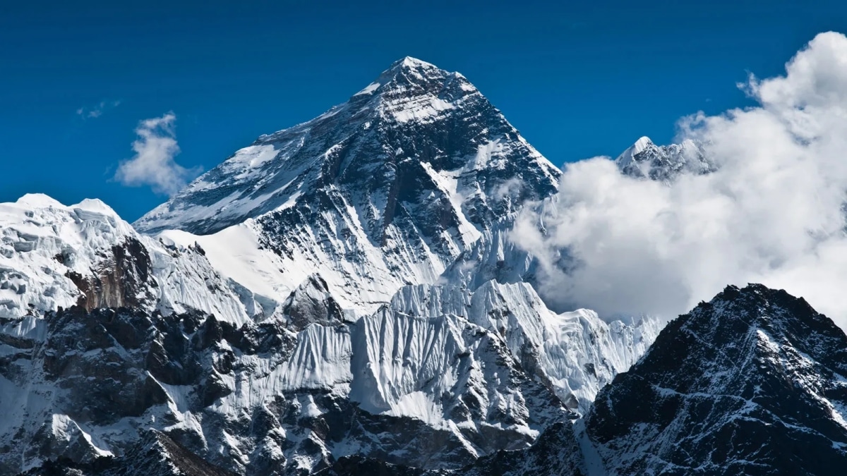
Mount Everest, standing at 8,848 meters (29,029 feet) above sea level, is the highest mountain in the world. Located in the Himalayan range, this iconic peak has fascinated adventurers and explorers for centuries. Understanding its precise location involves exploring its geographic coordinates, the borders it straddles, and its positioning within the majestic Himalayan landscape.
Contents
Geographic Location
General Location
Mount Everest is part of the Himalayan range, which stretches across five countries: Bhutan, China, India, Nepal, and Pakistan. The Himalayas are home to some of the highest peaks in the world, with Everest being the most renowned among them. Mount Everest’s location in this range underscores its prominence and the formidable challenge it poses to climbers.
Coordinates
Mount Everest is situated at 27.9881° N latitude and 86.9250° E longitude, within the Mahalangur range of the Himalayas. Understanding these coordinates is crucial for mapping and navigation purposes, especially for those embarking on expeditions to the summit.
Borders
Mount Everest straddles the border between Nepal and China’s Tibet Autonomous Region. This unique positioning makes it accessible from both countries, each offering distinct routes to the summit. The southern route from Nepal is more popular, while the northern route from Tibet provides an alternative approach for climbers.
Detailed Regional Location
Nepal Side
On the Nepalese side, Mount Everest is located in the Solukhumbu District, within the Sagarmatha Zone. The Nepalese name for Mount Everest is Sagarmatha, which means “Forehead in the Sky.” The Everest Base Camp trek from Nepal typically begins with a flight into Lukla, followed by a trek through the Khumbu Valley, passing through villages such as Namche Bazaar, Tengboche, and Dingboche. The South Base Camp is at an altitude of 5,364 meters (17,598 feet).
Tibet Side
From the Tibetan side, Mount Everest is located in Tingri County within the Shigatse Prefecture. Known as Qomolangma in Tibetan, meaning “Holy Mother,” the northern approach to Everest Base Camp involves a drive from Lhasa, the capital of Tibet, followed by a journey through high-altitude plateaus and valleys. The North Base Camp is at an altitude of 5,150 meters (16,896 feet).
Surrounding Geography
Himalayan Range
The Himalayan range is a vast mountain system that spans five countries and includes some of the highest peaks on Earth. Mount Everest is a part of the Mahalangur Himal sub-range, including other notable peaks such as Lhotse (8,516 meters) and Nuptse (7,861 meters). The range was formed by the collision of the Indian and Eurasian tectonic plates, resulting in the uplift of these magnificent mountains.
National Parks
Mount Everest is protected by national parks on both sides of the border. In Nepal, Sagarmatha National Park encompasses the southern approach to Everest. It is a UNESCO World Heritage Site known for its stunning landscapes, diverse flora and fauna, and cultural heritage. In Tibet, Qomolangma National Nature Preserve protects the northern slopes of Everest and the surrounding area, focusing on conservation and sustainable tourism.
Climbing Routes and Base Camps
South Base Camp (Nepal)
The South Base Camp is the starting point for the most commonly used route to Mount Everest’s summit. Located at 5,364 meters, it serves as the staging area for climbers making their final preparations before attempting the ascent. The route from the South Base Camp involves crossing the Khumbu Icefall, ascending the Western Cwm, and navigating the Lhotse Face before reaching the South Col and the summit.
North Base Camp (Tibet)
The North Base Camp is less frequented but offers an alternative route to the summit. Situated at 5,150 meters, it provides access to the northern route, which includes traversing the Rongbuk Glacier, climbing the North Col, and making the final push to the summit via the Northeast Ridge. This route is considered to be technically challenging but offers a less crowded approach to the top of the world.
Historical and Cultural Context
Historical Significance
Mount Everest has a rich history of exploration and mountaineering. British expeditions made the first recorded attempts to summit Everest in the early 20th century. In 1953, Sir Edmund Hillary of New Zealand and Tenzing Norgay, a Sherpa of Nepal, became the first climbers to reach the summit. Since then, thousands of climbers have attempted to conquer Everest, each contributing to its storied history and enduring allure.
Cultural Significance
Mount Everest holds deep cultural significance for the people of Nepal and Tibet. For the Sherpa community, who inhabit the Khumbu region, Everest is a sacred mountain known as “Chomolungma,” meaning “Mother Goddess of the World.” The mountain and its surrounding areas are dotted with monasteries, stupas, and prayer flags, reflecting the region’s spiritual importance. Climbing expeditions often seek blessings from local monks before attempting the ascent.
Conclusion
Mount Everest, with its unparalleled height, extreme cold temperature, and challenging terrain, continues to captivate the imagination of people worldwide. Its location, straddling the border between Nepal and Tibet, places it at the heart of the majestic Himalayas. Understanding Mount Everest’s geographic, historical, and cultural context enhances our appreciation of this extraordinary natural wonder. Whether approached from Nepal’s bustling trails or Tibet’s serene plateaus, Everest stands as a testament to human endurance, exploration, and reverence for the natural world.